
FAA Part 107 Study Guide
Aeronautical Charts
In the Airspace study guide, we discussed different types of airspaces and illustrated how they are displayed on sectional charts.
The FAA publishes 3 types of aeronautical charts for for pilots and remote-pilots operating visually (VFR/ Visual Flight Rules), each with a different scale (≈ “zoom level”).
World aeronautical charts (WACs) have a 1:1,000,000 scale and cover very vast areas, typically these will not be used by remote-pilots due to lack of detail.
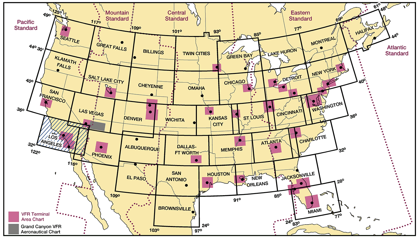
Sectional Charts have a scale of 1:500,000 (1 inch = 6.86 nautical miles (NM) or approximately 8 statute miles (SM)) and are very commonly used. Each black rectangle in the illustration represents a different sectional chart.
Terminal Area Charts (TACs) provide a large scale of 1:250,000 (1 inch = 3.43 NM or approximately 4 SM). These charts are available for dense airspaces found around metropolitan areas and are shown in pink on the above illustration.
If available for your area, you should use the TAC rather than the Sectional as it is much more detailed.
Where to find charts?
- Digital versions of charts are available for free from the FAA HERE.
- Private companies offer great apps or web tools containing FAA official charts. A great tool available for free is SKYVECTOR.COM.
- Paper copies can be purchase at local or online pilot shops for under $10.
Reading Charts
The best way to become familiar with a TAC or Sectional is to use the attached legend. Note that this same legend is found at the beginning of the Testing Supplement you will use during your knowledge test, this is a great tool to help you answer Chart and Airspace questions.
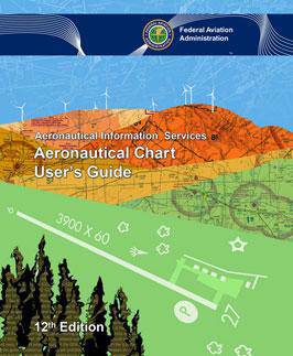
Comprehensive information can be found in the FAA Aeronautical Chart User’s Guide AVAILABLE HERE.
Latitude and Longitude
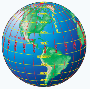
The Earth is divided in an imaginary grid pattern which allows us to identify any geographical point the planet.
The equator is an imaginary circle equidistant from the poles of the Earth. Circles parallel to the equator (lines running east and west shown in yellow above) are parallels of latitude. They are used to measure degrees of latitude north (N) or south (S) of the equator. The equator being parallel 0.
The angular distance from the equator to the pole is one-fourth of a circle or 90°. The 48 conterminous states of the United States are located between 25° and 49° N latitude
Meridians of longitude are drawn from the North Pole to the South Pole and are at right angles to the Equator. The “Prime Meridian,” which passes through Greenwich, England, is used as the zero line from which measurements are made in degrees east (E) and west (W) to 180°. The 48 conterminous states of the United States are between 67° and 125° W longitude.
To remember which line is which, think of latitude as “altitude”, “how high over the equator”.
To express the location of a point, one must use both latitude and longitude, for example San Francisco is approximately located at 38ºNorth (of the equator), 122º West (of the Greenwich meridian).
To pinpoint a precise point on Earth, we need more accuracy than a degree of latitude or longitude. Historically, degrees are divided in minutes and seconds (1 degree = 60 minutes, 1 minute = 60 seconds) . Recent systems like GPS use decimals instead.
The Golden Gate bridge is located at 37.8199° N, 122.4783° W,
or 37 Degrees 49 minutes and 12 seconds North, 122 degrees, 28 minutes 42 seconds West,
or 37º 49’ 23″ N, 122º 28’ 42” W
Sample Question

Refer to the figure above. What is the position of the Catalina Airport in Degrees Minutes?
Explanation

- Locate the airport
- Locate the grids of latitude and longitude, and their value.
- Count tick marks, each equates to 1 minute, with slightly larger ones at 5 and 10 minute intervals. The grids makes squares 30 minutes wide ( which is half a degree)
The US is in the Northern Hemisphere, and West of the Greenwich meridian, so degrees of latitude increase as you go North (think “up” is more) and longitude increase as you go West (think West is best, East is least)
The answer is 33º24’N, 118º25’W.
What if I need this converted to decimal?
1 degree is 60 minutes or 100 hundredths of a degree.
100/60 ≃ 1.66
Multiply minutes by 1.66
33.4ºN , 118.4ºN
Converting back to minutes and seconds is done by multiplying the fractional numbers by 60.
Sectional Chart “Airport data”
(Refer to FAA-CT-8080-2G*, Figure 22, area 2.) At Coeur D’Alene which frequency should be used as a Common Traffic Advisory Frequency (CTAF) to monitor airport traffic?
A. 122.05 MHz.
B. 135.075 MHz.
C. 122.8 MHz.
When taking the knowledge test, you’ll be given a printed copy of this TESTING SUPPLEMENT. Remember to look at the Appendix which contains a Aeronautical Chart legend.
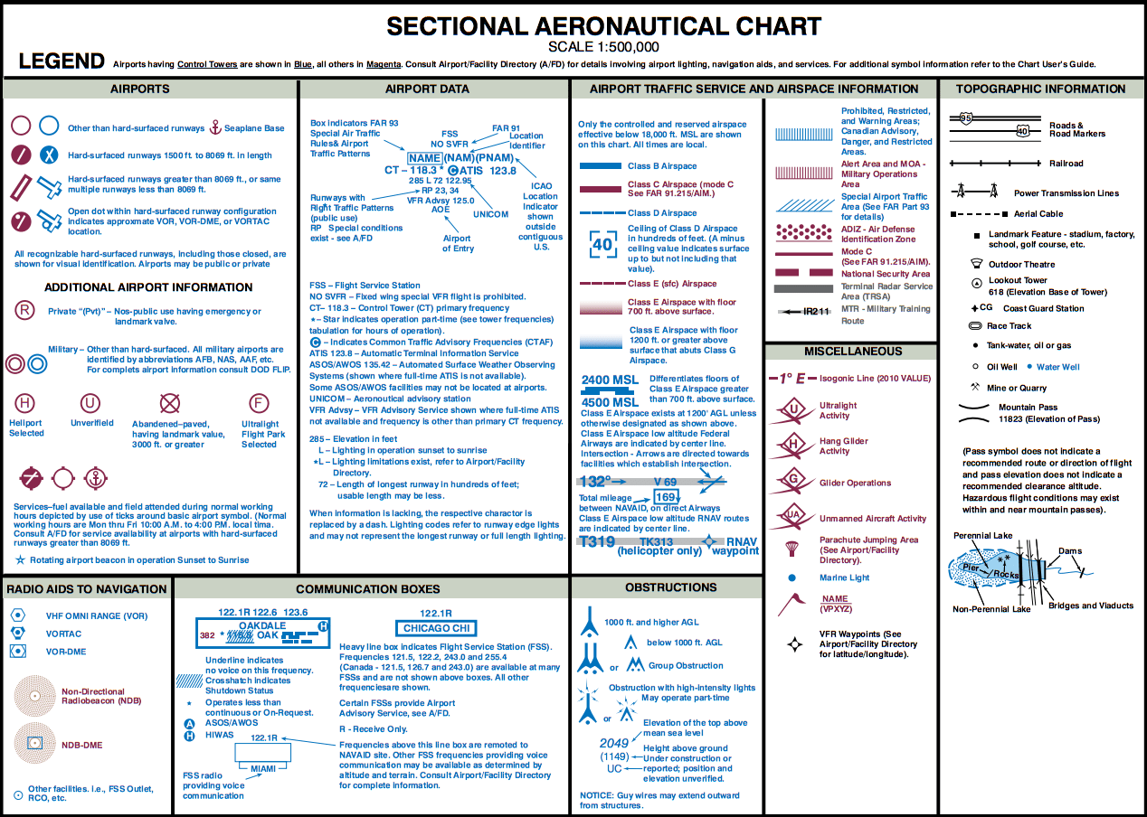
Locate figure 22, and take a look at Area 2 as noted in the question.
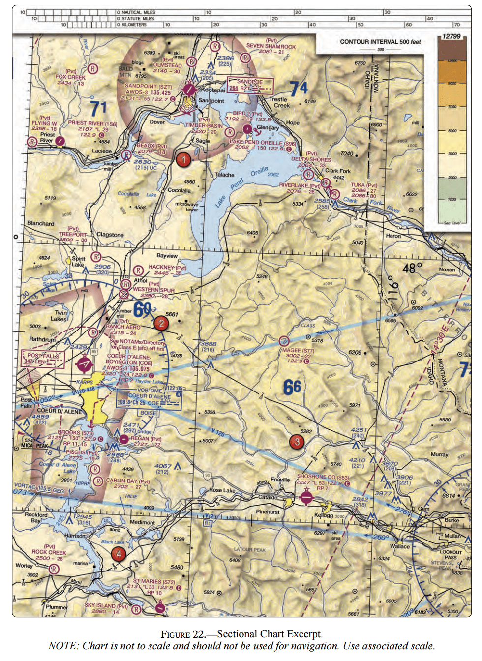
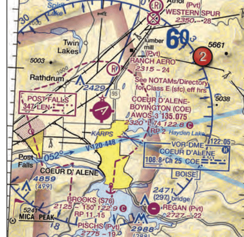
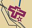

Notice that the airport symbol above is magenta, this indicates that the airport is uncontrolled – there is no ATC on the field. If the airport did have control tower, the airport symbol would be blue.
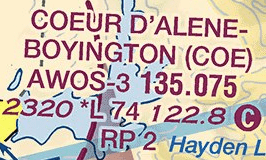
To the right of the airport symbol is the airport data. The airport’s name is “Coeur D’Alene-Boyington”.
The 3 letter airport identifier is “COE”
The airport has an AWOS-3, Automated Weather Observation System, available on frequency 135.075. As its name states, this system provides an automated weather report that is continuously updated and broadcasted on 135.075 Mhz. Use an aviation hand-held radio to listen to it. LISTEN TO AN AWOS IN THIS VIDEO, or learn more in THIS VIDEO COURTESY OF THE TENNESSEE DEPARTMENT OF TRANSPORTATION. The “-3” indicates the type of information delivered by the system. The higher the number (1-4), the more information is given. ASOS, Airport Surface Observation System, is a system with similar reporting to AWOS-3.
2320 is the airport elevation, in feet, above sea level.
L indicates that the airport has runway lighting, with the asterisk informing us that there is some form of limitation to that lighting, most likely that it is Pilot Controlled Lighting. To confirm this, find more information about the airport in the
74 is the length of the longest runway, in hundreds of feet. Here: 7400 feet.
Now to the answer, which can easily be found by simply looking at the legend from the Testing Supplement which you will have during the test.
“122.8 C, the “ ” symbol indicates that frequency 122.8 Mhz is the CTAF, Common Traffic Advisory Frequency.
Because this is an uncontrolled airport, pilots use this frequency to communicate their position and intentions with one another when flying within 10 miles of the airport. It is common for several airports to use the same CTAF.
As a remote-pilot, you should monitor this frequency using an aviation hand-held radio to stay aware of the position of manned aircraft around you.
Chart Supplements: the Airport information bibles
Nine regional manuals list public-use airports, seaplane bases, heliports, and military facilities.
The Chart Supplements contain information that can be important to Remote-Pilots including:
- Airport control tower hours of operation (a towered airport may be a uncontrolled class G early in the morning)
- Tower and airport manager contact information
- Control tower radio frequencies
- Automated weather information systems frequencies and phone number (AWOS, ASOS, ATIS)
Digital copies are available FOR FREE FROM THE FAA, printed version cost well under $10 and are available at any pilot shop.
Most of the content in these books is abbreviated or codified, the key to understandin it is once again the legend and *the sample airport located at the beginning. *
This legend will be available to you during the knowledge test in Testing Supplement Book.
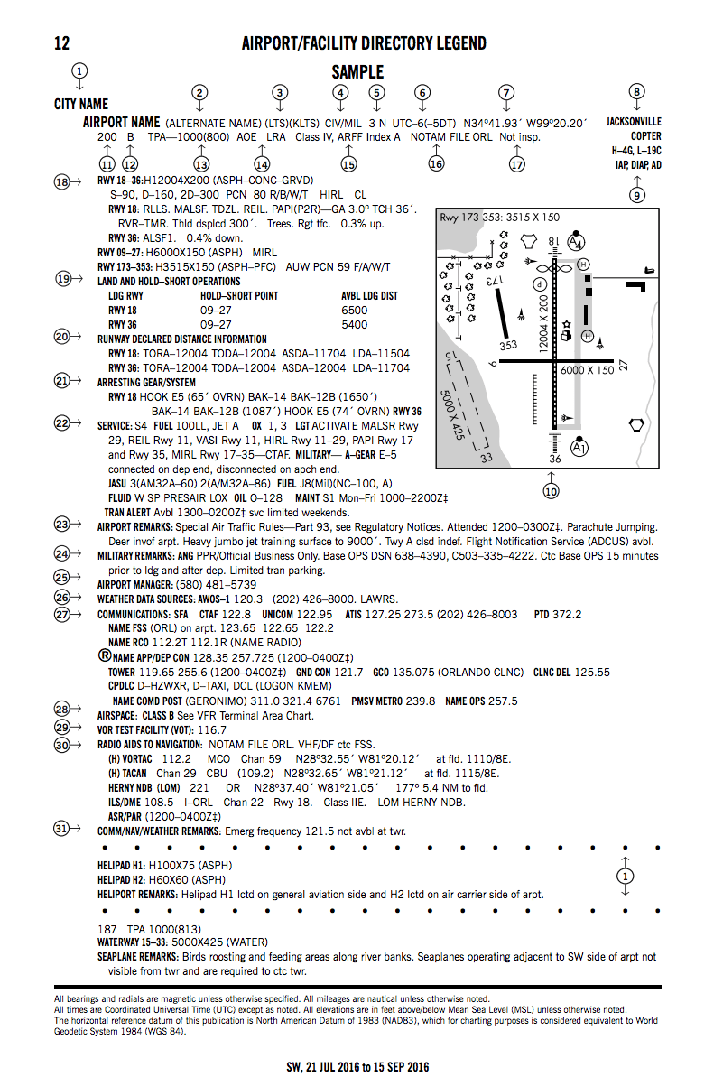
Locate the number associated with the piece of information you need to learn more about.
For example: “Weather Data Sources: AWOS-1” is numbered 26
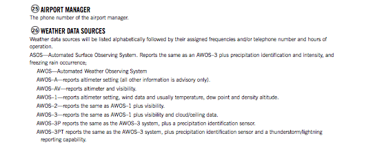
A few pages further, locate the description for number 26 and find plenty of information regarding Weather Data Sources.
This comes in very handy during the test.
Interested in working with us?
We are always looking to partner with like-minded organizations and to hire talented people. Send us a message to start the conversation.