
FAA Part 107 Study Guide
Airspace
Just like you would use a map to understand how to get from point A to point B, the FAA uses a map to divide and classify all of the vertical space, starting from just above the ground to 18,000 ft and higher.
Classifying types of airspace helps us understand whether airplanes or other vehicles might be occupying the same airspace as us. Understanding types of airspace and the rules that apply helps us avoid interfering with any other aircraft.
Of course with UAVs, we care most about airspace at the lowest altitudes, specifically 0-500ft Above Ground Level (AGL). If you recall, sUAVs are not permitted to fly above 400ft. This guide focuses on airspaces relevant to sUAS operations: those present at ground level and at low altitudes.

Classes of Airspace
| Airspace | Think | Airport Traffic Control Permission | Symbol on a map (Don’t forget there’s a legend in your supplemental material!) |
|---|---|---|---|
| Class A | High Up | Prohibited | Not shown (Over 18,000 feet) |
| Class B | Biggest Airports | Yes (Check for altitude notation) | Solid Blue Line |
| Class C | Large Airports | Yes (Check for altitude notation) | Solid Magenta Line |
| Class D | Medium Airport | Yes (Always starts at the surface) | Dashed Blue Line |
| Class E with an airport | Small Airport | Yes (Check for altitude symbol) | Dashed Magenta Line |
| Class E without an airport | Almost everywhere but at the surface | No | Gradient Blue or Magenta Line (and certain Dashed Magenta Line areas – see below) |
| Class G | Good to Go! | No (ATC doesn’t exist!) | Everywhere else. |
Special Use Airspace (SUA)
| Type | Legend | Flight Allowed |
|---|---|---|
| Prohibited | Blue hatched line with name starting with P. Ex. P-49 | No |
| Restricted | Blue hatched line with name starting with R Ex. R-2079 | If active (“hot”), no unless with explicit permission, check legend. If inactive (“cold”), flight is allowed. |
| National Security Areas | Purple box with callout | Technically yes, but that is poor judgement. |
| Warning areas, Military operating areas (MOAs) and Alert areas | Magenta hatched line with name (Alert, MOA) except Warning Area: Blue hatched line | Yes, with caution. |
| Military Training Routes (MTR) | Gray line with name. Below and above 1,500 ft: IR1206, VR1207 Below 1,500 ft only: IR206, VR207 | Yes, with caution, get a brief @ 1800wxbrief.com or by calling 1800-WX-BRIEF |
| ADIZ – Air Defense Identification Zones | Line with dots (border regions) | No |
| Temporary Flight Restrictions (TFR) | Not on charts! Places with: sporting events Aerial fire fighting air shows rocket launches Presidential movements | No. Check at tfr.faa.gov, 1800wxbrief.com or by calling 1800-WX-BRIEF |
Representing Airspace
Class A (Alpha) Airspace – starts at 18,000 feet AMSL (Above mean sea level), this airspace is not a factor for Small UAS operations. Class A Airspace is not shown on charts.
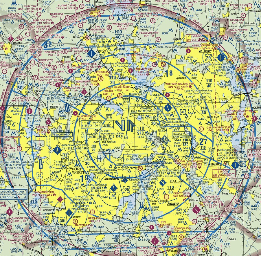
Class B (Bravo) Airspace (shown above) – Surrounds the nation’s busiest airports such as JFK, SFO or DFW, this airspace typically consists of a surface area up to 10 nautical miles (NM) wide and two or more layers extending laterally up to 30 NM from the airport. ATC approval is required to operate in Class B.
Airspace is 3 dimensional, a chart isn’t. There’s always several layers of airspace over your head.
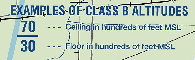
The floor and ceiling of the airspace are shown (bottom and top), in hundreds of feet, above Sea Level (AMSL).
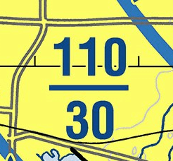
Here, the class B starts at 3,000 feet, and ends at 11,000 feet. Because the airspace starts well above where you would normally be flying, it should not be a concern to a sUAS operator.
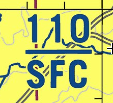
Here, the class B starts at the surface (SFC), and ends at 11,000 feet. ATC Permission is required to fly here.
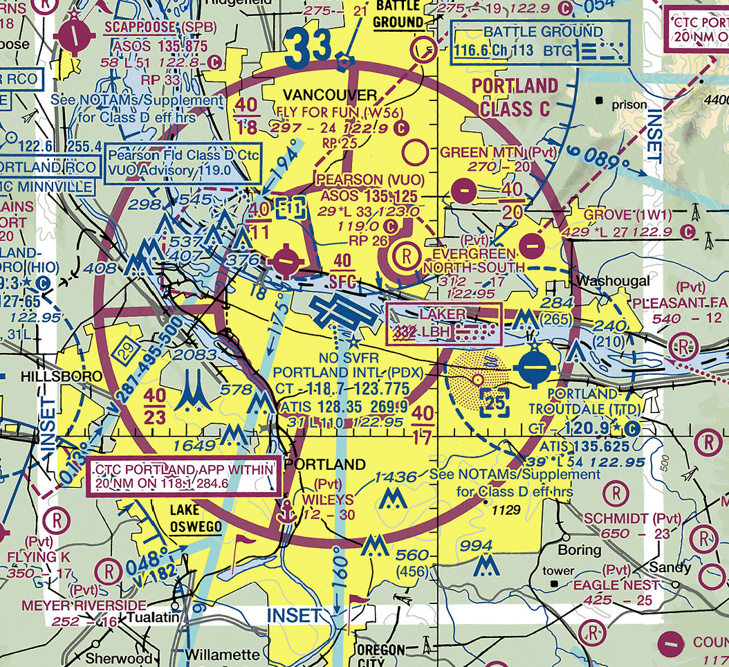

Class C (Charlie) Airspace – Designed to protect aircraft operating in and out of large to medium-size airports such as Oakland or Portland. The airspace configuration varies but usually consists of a surface area with a 5 nautical mile (NM) radius and a circle with a 10 NM radius that extends no lower than 1,200 feet above the airport elevation. ATC approval is required to operate in Class C.

Class D (Delta) Airspace – ** This airspace always starts from the surface** and typically, extends 3 to 5 NM laterally, it surrounds all other airports that have an operational control tower (not Class B or C). ATC approval is required to operate in Class D.
Because Class D always starts at the surface, only its ceiling is shown on charts (in hundreds of feet).
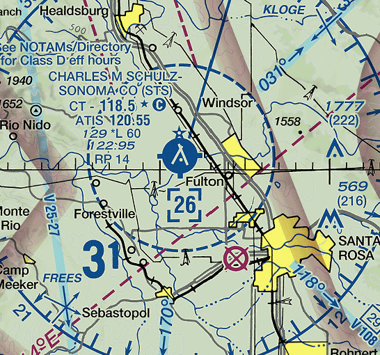
Class E of an airport from the surface. ATC Permission required. Class E surface extensions do not require authorization (see below)
Class E surface extensions (without an airport inside them) do not require authorization. (See dashed magenta line East and North-West of the Class D airport) The class D area (dashed blue area) does require an authorization.
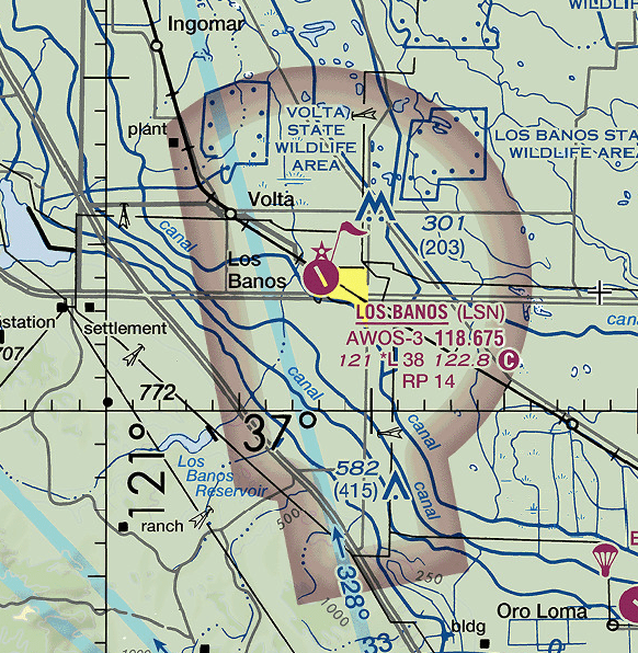
Class E from 700 ft above ground, no ATC permission required.
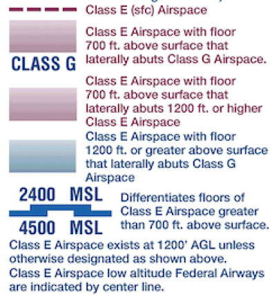
Class E (Echo) Airspace – Any airspace not classified as A, B, C or D but that is controlled is Class E airspace.
This airspace extends upward from either the surface (sfc) when associated with an airport, or a designated altitude of 700 or 1200 feet above ground most commonly. It contains all airport instrument approach procedures and Federal airways.
*ATC approval is required to operate in any Surface Class E associated with an airport, it is not required in other forms of Class E. *
*Class E is symbolized differently depending whether it starts at the surface or at a higher altitude, see legend above. *
Uncontrolled Airspace
Class G (Golf) Airspace – all airspace that is not designated as Class A, B, C, D or E, it is not explicitly charted. This is uncontrolled airspace; no ATC is available in Class G, thus no permission is required to operate. Note that uncontrolled does not mean unregulated and other Part 107 limitations still apply.
Obtaining ATC authorization
ATC Authorization cannot be requested on the radio or phone, this request must be done online through the WAIVER APPLICATION FORM on the FAA website or directly through the Site Scan app if LAANC is available.
More On Special Use Airspace (SUA)
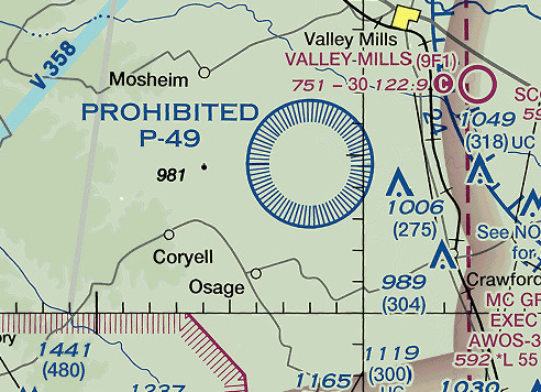

Prohibited areas are established for security or other reasons associated with the national welfare. Prohibited areas are charted with an “P” followed by a number (i.e. P-49) Flight of aircraft is prohibited at all times.

Restricted areas are designed to protect aircraft of dangerous activities that occur in them such as artillery firing, aerial gunnery, or guided missiles. Flight of aircraft, while not wholly prohibited, is subject to restrictions. Flying in an active restricted area without authorization from the controlling agency is prohibited.
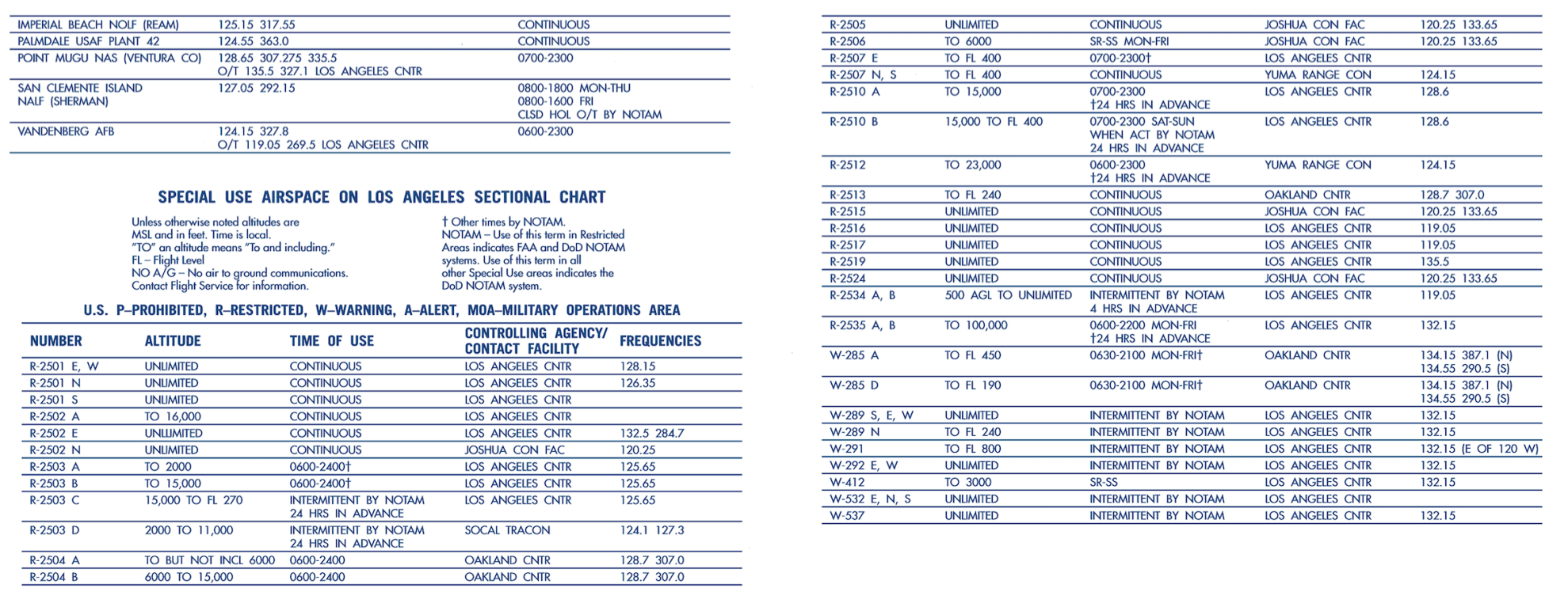
Restricted areas are charted with an “R” followed by a number (i.e. R-2503), their hours of activity, controlling agency and additional information are listed on the legend of sectional charts.
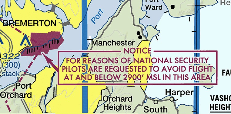
National Security Areas inform pilots of locations where there is a requirement for increased security and safety of ground facilities. Pilots are requested to avoid flying through the depicted NSAs.
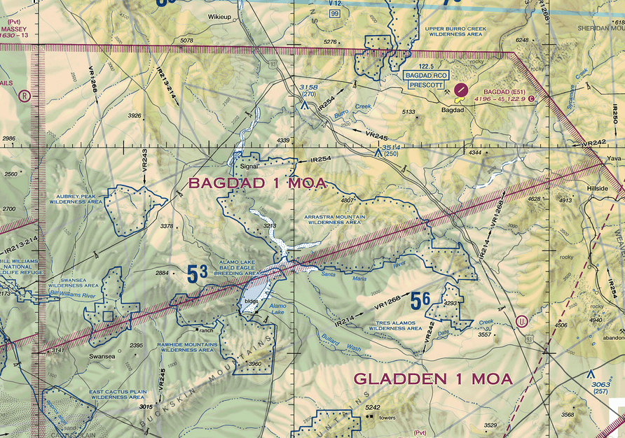

Warning areas, Military operating areas (MOAs) and Alert areas are other airspaces defined on aeronautical charts in which extreme vigilance should be exercised due to unusual or dangerous activity, however flight in these areas is not prohibited.
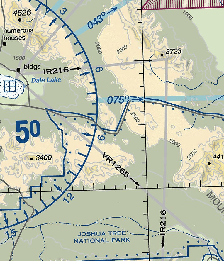
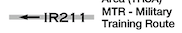
Military training routes (MTRs)
MTRs are routes used by military aircraft for training activities, low altitude and very high speed flight training happens along these routes. There are Visual Routes (VR), and Instrument Routes (IR).
MTRs with no segment above 1,500 feet AGL are identified by four numeric characters (e.g., IR1206, VR1207).
MTRs that include one or more segments above 1,500 feet AGL are identified by three numeric characters (e.g., IR206, VR207). Yes, this may be asked on the test.
Caution should be exercised when operating along or near MTRs.
Remote-pilots can obtain information on activity along MTRs by obtain a preflight briefing from Lockheed Martin Flight Service at 1800wxbrief.com or by calling 1800-WX-BRIEF.
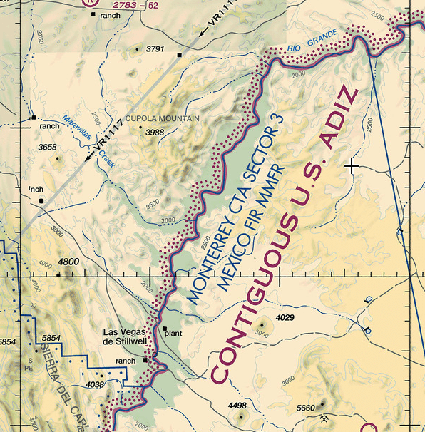

ADIZ – Air Defense Identification Zones are present along the borders of the contiguous US and around Alaska and Hawaii. SUAS may not cross an ADIZ without ATC and Customs/Border Patrol permission.
While not regulated by the FAA, other areas such** National Parks or certain cities have banned the use of drones**. Certain parks or wildlife refuges are charted.
Following the terrorist attacks of 2001, the FAA issued a Notice to Airmen which strongly advises avoiding flight over sensitive areas such as power plants, refineries, dams, and similar facilities. Please exercise good judgement and fly responsibly.
Temporary Flight Restrictions (TFR)
A TFR is a short-term, airspace restriction in a defined area. A Notam (Notice to Airmen) is published by the FAA to announce Temporary flight restrictions. Some of the many reasons that could lead to their creation are as follows:
- Sporting events
- Aerial fire fighting
- Air shows
- Rocket launches
- Presidential movements
TFR sizes vary greatly, starting from the surface with a 3 nm radius and 3000 ft high for a sporting event, to 30 nm radius and 18000 ft high for a presidential movement. TFRs are published on TFR.FAA.GOV, however to be certain to obtain up to date information, you must obtain a briefing from the nearest Flight Service Station by calling 1-800-WX-BRIEF or using 1800WXBRIEF.COM.
Flight in a TFR is prohibited unless authorized by ATC.
Note that TFR’s for sporting events are typically not shown on the aforementioned website, and occur from one hour before the official start of the event to one hour after it ends.
Also some TFR’s aren’t very “T” (Temporary), the Disneyland and DisneyWorld TFR’s have been in effect for over 10 years, but still apply to sUA operators.
Interested in working with us?
We are always looking to partner with like-minded organizations and to hire talented people. Send us a message to start the conversation.