
FAA Part 107 Study Guide
Introduction to airport operations and communications.
To avoid avoid interfering with manned aircraft, it’s important to understand operations around airports, including the different types of airports:
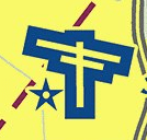
Towered/controlled airport are shown in blue on aeronautical charts. ATC permission is required to operate in their airspace.
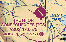
Uncontrolled airports do not have a control tower. Pilots communicate their position and intentions with one another on the Common Traffic Advisory Frequency (CTAF) These airports are shown in magenta.

Heliport are typically uncontrolled. Pilots may communicate on the CTAF or with the nearest Towered Airport.

Seaplane bases are typically uncontrolled and have a CTAF.
Regardless of the requirement to have ATC permission or not, you should listen to nearest Tower or CTAF frequency, as far as 10 miles away, to maintain situational awareness of aircraft around you.
Around airports, aircraft typically follow a standard traffic pattern around the runway in use. The runway in use is the one facing into the wind.
Runways are numbered according to their compass direction or magnetic heading, without the last digit.
A compass is a 360° circle where 0/360° is North, 90° is East, 180° is South, and 270° is West.
For example, a runway oriented East (90º) to West (270º) would be Runway 9 when taking off or landing towards the East and Runway 27 when taking off/landing to the West.

L (Left) or R (Right) can be added to differentiate parallel runways. (i.e Runways 27R and 27L)
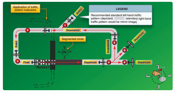
Tower will instruct aircraft, or at uncontrolled airports aircraft will announce what they are doing, by using standard terms to describe their position around the airport (shown in yellow above).
A standard traffic pattern, as shown above, is flown making left hand turns at an altitude of 1000 feet above airport elevation (TPA = Traffic Pattern Altitude). Non standard patterns (to the right) and altitudes are described in the Charts Supplement.
Using their onboard VHF radio, aircraft will communicate with other aircraft or with ATC by using standard phraseology.
You can listen to these communications by using an “Aviation Handheld Radio” that can be purchased from any pilot shop. No license is required to use one, but make sure to understand radio procedures and exercise good judgement before communicating on aviation frequencies.
For example in the figure above, the airplane in position one is coming in to land at “Berkeley airport” (uncontrolled)
“Berkeley traffic, Cessna Three Alpha Bravo, Left Downwind Entry runway 9, inbound for Landing, Berkeley traffic.”
The typical message will be formatted:
- Who you are talking to
- Who you are
- Where you are
- What you are doing or what you want
Who you are talking to: the name of the airport the aircraft is operating at followed by Tower when controlled, or Traffic when on the CTAF of an uncontrolled airport. (When uncontrolled, aircraft repeat this at the end of the message)
Who you are: The “callsign” which is the type of aircraft followed by it registration numbers (and letters), using the phonetic alphabet.
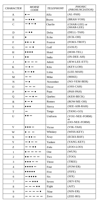
For a small Cessna with a registration N123AB, the callsign would be “Cessna One Two Three Alpha Bravo” or Cessna Three Alpha Bravo” for short.
For small UA, the callsign will be chosen by ATC if needed, like “Drone 1” or “Unmanned 1”
Where you are: position + altitude if outside the traffic pattern (always expressed above sea level).
“Left Downwind Entry Runway 09”
“Seven miles East of Berkeley airport at 3000 feet”
What you are doing (uncontrolled) or what you want (controlled airport)
“Inbound for landing runway 09” / “Request Landing runway 09”
Listen to an airport near you on LIVEATC.NET
Sample question:
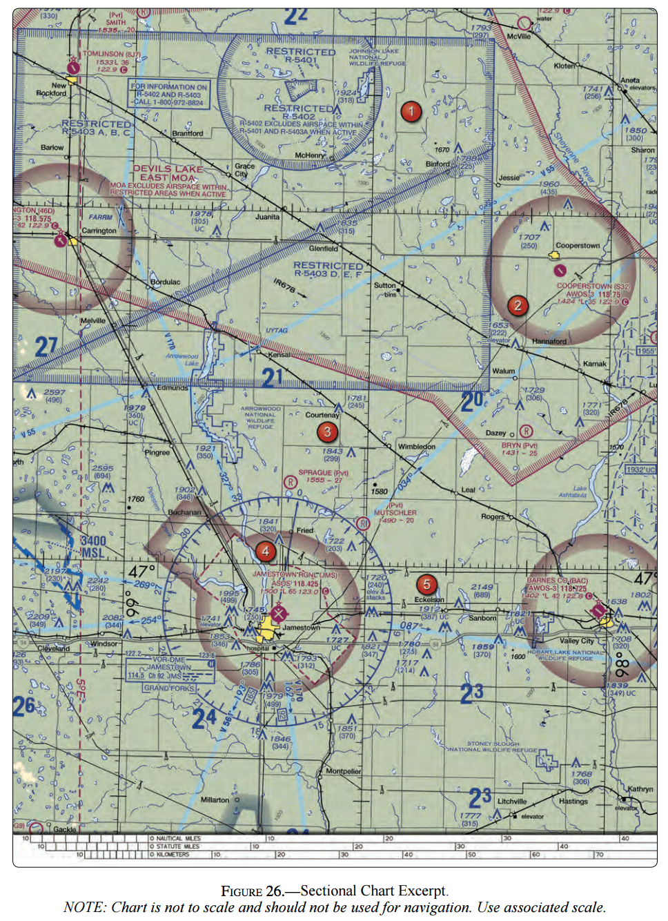
(Refer to FAA-CT-8080-2G, Figure 26, area 2.) While monitoring the Cooperstown CTAF you hear an aircraft announce that they are midfield left downwind to RWY 13
Where would the aircraft be relative to the runway?
A. The aircraft is East.
B. The aircraft is South.
C. The aircraft is West
Answer
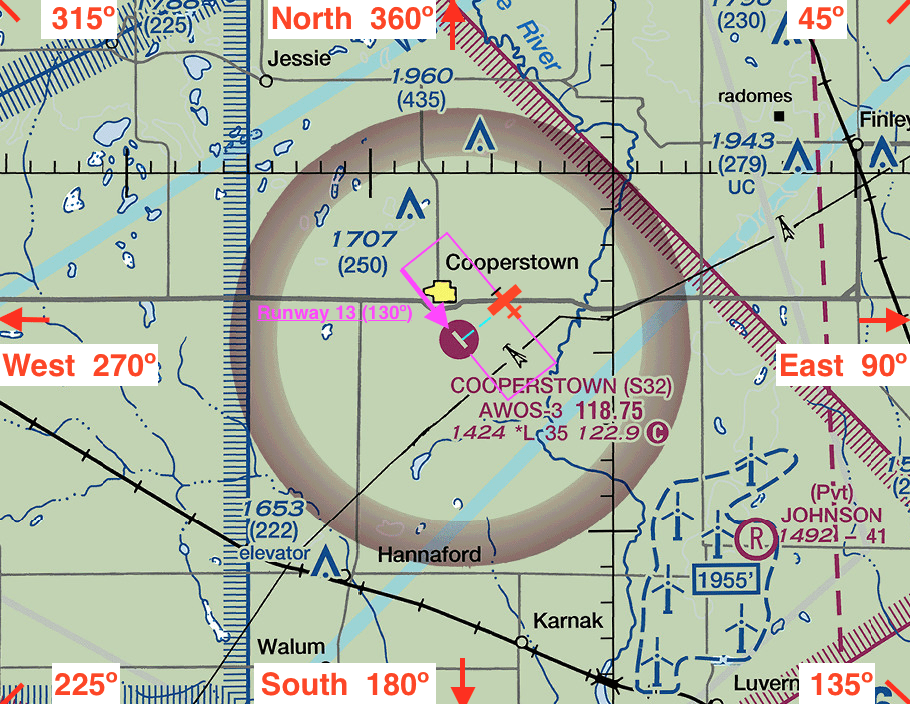
– 1. Locate the Cooperstown AIrport in Area 2 of the figure.
– 2. Determine which runway is runway 13. Because its called 13, you know the runway is oriented heading 130º. 90º is East, 180º is South, so 130º is approximately South-East.
– 3. On your scrap paper, draw out the traffic pattern. In this a case left traffic patter as if taking off runway 13.
– 4. Locate the left downwind leg of the traffic pattern. The aircraft is “midfield” meaning its wings are abeam the center of the airport.
A. The aircraft is East of the runway.
CHAPTER 14 OF THE PILOT’S HANDBOOK OF AERONAUTICAL KNOWLEDGE provides more details on airport operations.
More on Radio Procedures and Phraseology in the AERONAUTICAL INFORMATION MANUAL CHAPTER 4-2 and the PILOT/CONTROLLER GLOSSARY.
Interested in working with us?
We are always looking to partner with like-minded organizations and to hire talented people. Send us a message to start the conversation.